Places of Interest

The Eye
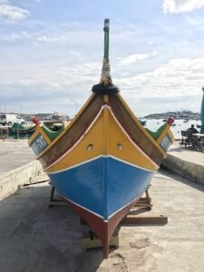
One of the many questions visitors seek answers behind reason for those eyes found on the boats. So here it goes.
 Mostly each boat has a pair of eyes. Sarcastically fishermen may tell you that that they can see where the fish are, but apart from humour it’s more of a tradition and superstition.
These eyes are a modern survival of millennia of Mediterranean sea-faring civilizations, beliefs and omens that date back to the old Phoenicians. This Civilization from the East Mediterranean coast, placed these symbol of their god Astarte, The Phoenician God of protection from evil. Those eyes are the symbols of good health and to protect travellers on their exploits.
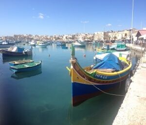
The Egyptians equivalent god would put eyes of Horus on the front of their boats, which is a symbol of protection. Sooner other Mediterranean Cultures also placed eyes on their boats just calling to their gods for protection on the waters that they sail on. It is said the Greeks used marble eyes on their ships avidly believing that it would bring them luck and if they listened they would not be shipwrecked and the boat would see around obstacles.
The Romans also followed this by painting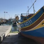 large eyes above their rams on their bows of their galleys to scare enemies and in some cases were used to show wealth and power should they belong to any patriarch family.
No evidence that Arab or Ottoman cultures ever followed the same practice as it was a belief that the evil eye concept is only akin with bad omen and misfortune.
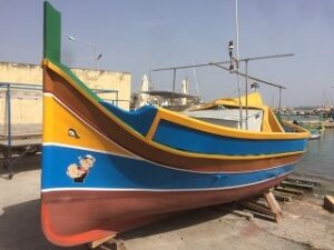
To sum up all these short historical facts the eyes today are either placed on boats to keep alive this Mediterranean folklore or for sheer believe in the superstation of good luck while in the open blue sea.

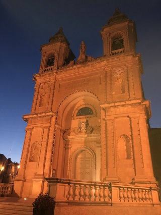
Tas-Silġ Church
 This church in Marsaxlokk is dedicated in devotion to Our Lady of Snow , founded on the land in the patronage of Giovanni Francesco Cassar in 10th November 1650, archived into the deeds by notary Natale Parmisciano.
In 1832, this church was demolished and rebuilt on the same foundations of the old church, but with a different design from that of 1670. This cost was borne by the Marquess Angelina and The Marquis Muscat Cassia Dorell. In her will by the deeds of the notary Massimiliano Troisi Murville of September 25, 1834, released some rights to whoever would be carer of this church with the adjacent Testaferrata Palace. Indications of an ancient tower foundations beneath the palace are also recorded.
The Skalzi Carmelite Friars asked their superiors for permission to take this place into their hands and accept whatever the original testator requested. On April 22, 1933, the contract was signed by the Marquis Lorenzo Testaferrata binding that this church, the palace, the garden, and other possession passed to these monks.
On April 8, 1934 three new bells added, built by Pasquale Marinelli e Figlio of St. Albert. and plans were made up to erect a convent adjacent to the palace.
This was finished on October 2, 1939  during which the war had already begun and the Friars, under Emergency law, had to give up this convent to the British Commander of Royal Engineers in service in the fortresses of Delimara and Tas-Silg close by.
On November 20, 1942 the military left this convent and eight days later the Friars blessed the place again and reopened it.
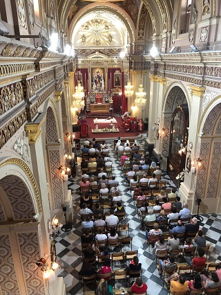
Today the church is under the care of the Terezian Carmelite priests ,they provide daily Masses and all liturgical functions throughout the year.
Three particular holidays are solemnly celebrated. These are the 4th of August, a titular feast of Our Lady of Snow; July 16, a feast of Our Lady of Mount Carmel, and October 1 a feast of St. Therese of the Baby Jesus

Salt Pans
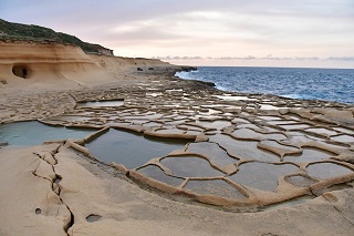 Malta does a great line of natural salts. Long before the development of food preservatives and the invention of refrigeration, salt was the only natural and widely available way of preserving food beyond immediate consumption.
Malta does not have any salt mines and it is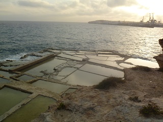 to the sea we look for salt production. There are about forty sites around the islands’ shores where sets of salt pans exist. These are mostly hewn out of the shallow living rock where the sea water retents and eventual drys up – leaving the precious crystal salt behind.
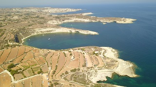
Salt pans are found mainly around Marsaskala and Delimara in the south of Malta while in Gozo there is a very large stretch of them along the northern coast west of Marsalforn.

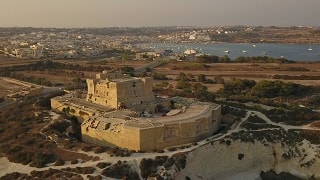
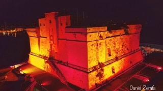
Sea Fortress - Delimara
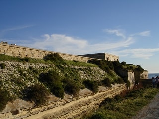
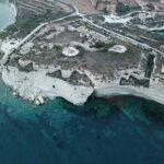 The fort was built between 1876 and 1888 by the British Military as part of a chain of defensive structures round the harbour. A nearby 17th century Delimara Tower (De Redin) was demolished to clear Fort Delimara’s line of fire.
Fort Delimara was a very complex project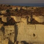 with mostly underground structures. The fort’s main armament mounted in six case-mates set on the cliffs facing the harbour entrance. Armed with 12.5-inch 38 ton rifled muzzle-loading guns was a monumental feat to place them inside the fort. These were ferried to a nearby beach pulled up in an uphill passage, purposely built all the way up, south western side of the fort.
 At the surface it is a polygonal fort with rock cut ditches on three sides. Glacis also surrounded the ditch and disrupted only at the main gate . An original rolling bridge that would originally have crossed the ditch has been replaced by a permanent bridge. Ventilation apertures and access passageways are spread out across the face of the cliff.
The ditches surrounding the fort are edged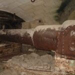 with the upper scarp textured in earth and rubble. A stone parapet with rifle loops runs along the top of the north scarp.. A World War II vintage pillbox has been erected inside the Fort, and shows above the fort’s profile when viewed from the sea. Additional anti air Bofors 40 mm gun emplacements on top of the case mates were built to suppress bombing runs and flight paths by axis warplanes.
In 1956 the fort was stripped of the majority of its artillery. Soon after, the fort was abandoned for a considerable period, and in 1975 it was leased by the Malta Government to a local farmer, who used it to raise pigs for fifteen years.
Four of its original complement of fourteen Victorian 12.5-inch 38 ton rifled muzzle-loading guns can still be found inside the fortress.
After much negotiations, ownership of Fort Delimara was transferred to Heritage Malta on August 11, 2005.
Externally the fort is in fair condition but the structure inside the parade ground and interior/underground garrison have also eroded. The immediate danger comes within the fort’s sea side, due to coastal erosion and wave action, parts of the nearby cliff face have already collapsed increasing the imminent danger of collapsing into the sea. The site remains open for any opportunity of patronage to save this fort but so far no plans to preserve this has yet been brought forward amidst pressure from the local community.

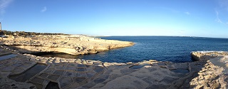
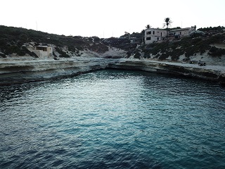
Il-Ħofriet Coves
 Il-Ħofriet, plural for two sea coves next to each other on larger than the other, therefore Il-Ħofra il-Kbira, the larger and il-Hofra iz-Żgħira, the smaller.
Both separated by a small tapering piece of land called Ras il-Fenek (Rabbit’s Point), with is popular seacave in the middle.
During the heat of Summer the Il-Ħofra il-Kbira is a very popular swimming area with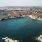 the locals, but most of all for mariners anchoring their boats and spend the days in this shelter.
The other cove is shunned for the reason of choice. A smal rock it-Taqtiegħa tal-Ħofra is located metres away from the shore.

The Parish Church
 In 1888 when the villagers held a meeting and discussed the need of a church to cater for their spiritual needs. They decided to present their proposition to the bishop of the time who agreed to the plan.
At the time the villagers were very poor and needed lots of financial help to fulfill their wish. The first help was provided by the noble family Zammit Gauci from Ħaż Żebbug who donated the land on which the church was eventually built whereas Dun Ġużepp Diacono, a Gozitan chaplain, designed the architectural plan of the building. Another source of great help was provided by the Marchioness Rosalia Sabbatini who married Giuseppe Apap Viani Testaferrata in 1887 and resided in the village.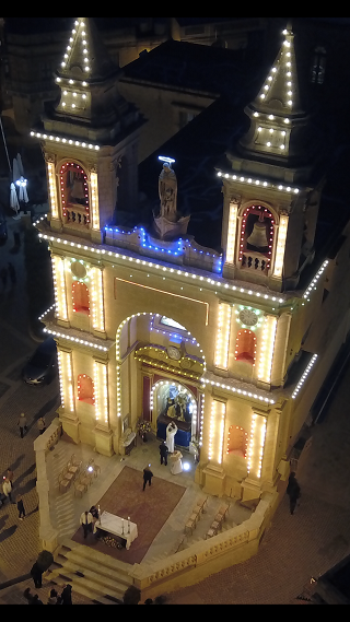
A couple of years before her marriage she had a terrible experience when the ship she was sailing on along the west coast of Italy was involved in a very violent storm. She feared for her life but somehow managed to make port in Corsica. The incident took place around midday when special prayers known as suppliki were being recited to Our Lady of the Rosary at Pompeii. To this end the Marchioness attributed her miraculous survival to her divine intervention. In recognition to Our Lady’s benevolence Rosalia promised to build a church in Malta in her honour.
When she learned about the villagers’ wish to build a church she offered to make good for half of the expenses required in its building if they agreed to dedicate the church to Our Lady of the Rosary at Pompei to which the villagers consented.
The foundation stone of the church was laid on the 7th of December 1890. The actual building which was supervised by the expert master mason Karmenu Vella took more than two years to complete however it must be noted that the original church was far smaller than the present one and consisted only of the present day nave.
The church was blessed on the 25th of September 1892.
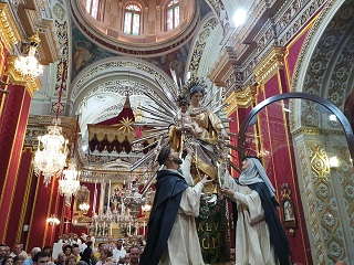
Nowadays, the church which has since been elevated to the state of a Sanctuary, can be admired in its full glory. Between the bell towers of the facade, one can admire the beautiful sculpture of Our Lady of Pompei on board a traditional Maltese fishing boat to reflect the village’s long standing tradition.

Torri Bettina u Kappella San Pawl
 Saint Paul’s Chapel and the adjacent Tower were built and upgraded gradually. From 1740 by Eliżabetta Muscat Cassia Dorell, rebuilt in 1831 by her daughter Marchioness Angelica Moscati Cassia Dorell and restored in 1931 by Angelo Muscat Cassia.
The tower consists of three rooms at ground floor level, used for residential purposes. The rooms consist of a high ceiling and are very well kept. The living area is part of the tower and has arched ceilings. The two storey L-shaped tower has a plain external appearance with the lower part having a slight slope.
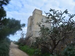
There is a plain projecting string course between the ground and first floor. It also has a number of small window openings and machicolations or drop boxes for the throwing of projectiles or boiling liquid on besiegers.
Both Ta’ Bettina tower and the chapel are privately owned and are inaccessible to the public.

Fort St. Lucian
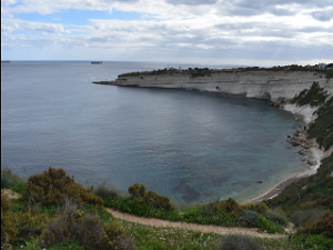
A large fortification that was built at a time when the south of Malta was exposed to the deprivation of corsairs and Pirates. Every summer the islands like many other islands in the Mediterranean ended up being the target of the Barbarians who would not only land, but would leave a great ruin and drag towards their land both people, property and also livestock and crops as well.
Therefore the Maltese people who lived in the southern part of the island begged the Grand Master of that time to build a series of Fortifications and protect the coast of Malta which in fact they constructed – towers such as St. Lucian’s Tower.
This tower was thought to have a large number of cannons to enable them to defend not only against landing but also if attacked from inland. So it had cannons on the roof and around it. One enters this tower finds that it is built bomb proof, – therefore with its roofs made up of very strong trolls (rounded stones).
The fort itself was accessed by a draw bridge which is unfortunately no longer there today. Draw bridges were used in the large towers to protect the entrance, which is considered to be the weakest point in the structure in all the fortifications.
When the British came, although there were recommendations to demolish it and instead build a more modern Fortress, they recognized its importance and instead they reformed it by building a new Battery on almost the same concept that there was of the knights, but much bigger and stronger. They completely surrounded the same tower. and made a mold, even though this ditch was without water. It is also divided by caponiers.
The tower or Fort St. Lucian is one of the most beautiful Fortifications we still have in the Maltese islands. It is a Fort that not only goes back to the time of the Knights but testifies to everything that has happened in Malta for over then three hundred years when it comes to the development of the heritage of coastal defense in these islands.
It is a very important place that should be given great importance not only from the historical point of view, but also from its architectural point of view. It is a great gem to be appreciated and protected.

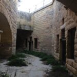
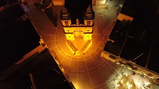
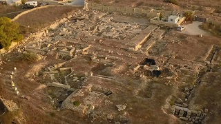
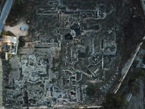
Fort tas-Silġ
Fort tas-Silġ is a British era polygonal fort 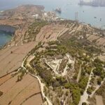 built between 1879 and 1883 on high ground above il-Ħofra-iż-Żgħira, a nearby inlet. Its primary function was as a fire control point controlling the massed guns of Fortress Delimara at the furthest point of the Peninsula guarding the harbour entrance.
The first stone of Fort Tas-Silġ was laid down in 1879 by British Royal military engineers, and it was completed in 1883.The fort is a classic example of a polygonal fort with underground barracks, magazines and a parade ground. It is surrounded by a ditch, and the entrance was protected with gun ports on one side and a bridge leading to the door.
During both World Wars, the Fort served as a garrison and in the latter, when radar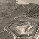 technology was in its infancy, Malta the British authorities decided to build an early-warning system. In Mid-July 1940 the third Air Ministry Experimental Station No. 501 AMES at Tas-Silġ was installed as a part of a chain of four radar system round the island, directing fighter squadrons and anti-air bofors guns.
In the 1950s the Fort was used as an ammunition depot by the RAF, later increasing it’s purpose for wireless communication, installing three advanced aerials on the camp.
The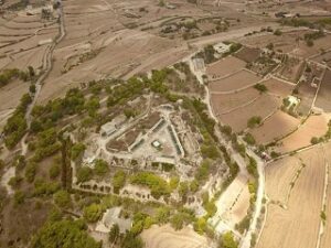 fort was finally decommissioned and handed to civilian authorities in 1960. Since 1991, the fort has been rented to the Island Sanctuary as a refuge for dogs.

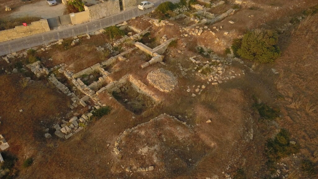
Tas-Silġ Temples
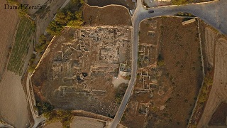 For four thousand years, Tas-Silġ has been a holy site during different historic-periods. On the high point a megalithic temple was built dating from the early third millennium BC until the Bronze-Age in adoration of the woman goddess of fertility
Around 700 BCe, the Phoenicians, later Carthaginians took over Malta and at the time built a Punic temple to their chief goddess Astarte and Tanit god of nature, on top of this temple.
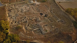
Greek and Egyptian Influence is also evident with artifacts dedicated to Hercules and the Sun god Ra respectively, where found in late excavations..The goddess Hera, wife of Zeus was also enshrined in these temples during this period.
In 218 BCe Malta, Melita at the time, fell from Carthage’s hand during the second Punic war to the Romans, given an autonomy as a free municipium and an important trading post for the Roman Empire. Yet again the Romans converted this complex dedicated to the mother goddess Juno. At the time, the visible location along it helped seafarers to navigate as the harbour was part of a major maritime trading route.
Rome lost the islands during the mid 5th century when the island were invaded by the Vandals and settled for a short period, until the Byzantine conquest of Sicily. Subsequently the temple was converted into a Christian Basilica which remained in use until the early 9th century. A fortified wall with at least one tower was built around part of the site, with its expansion linked with Marsaxlokk harbour below, possibly as a response to the Arab threat.
Soon after the islands fell to the Aghlabids Arab defeating the Byzantines in 870 CE .It is proven, that the site was was pillaged and burned down during the Arab period however claims that mosque stood on site, is not supported due to lack of concrete proof. Farms were built on the area, and the whole site was buried under a metre of soil.
.
The site was discovered in the late 17th century with its famous discovery of the Cippus of Melqart. The Cippi of Malta are a pair of ornamental pillars with engravings dedicated to the god Melqart, the guardian Phoenician god possibly with the involvement of Hannibal. Around the 4th century BCe. the Greeks started to identify Melqart with their own legendary hero,Hercules. This inscription confirms the god Melqart and Heracles as being one, this shows how successfully the Phoenicians exported their gods and culture into Hellenistic and Roman successors. thus the Latin name of Marsaxlokk PORTUS ERCOLES.
The most important feature of these Cippi are the inscriptions, inscribed in two languages corresponding the Ancient Greek and the Phoenician Alphabet., a major breakthrough in Archaeology as both languages where finally deciphered. Today One Cippi is found at Louvre museum in Paris, and the other at the National Archaeological Museum of Malta.
A local myth of a legendary golden calf also exists, due to eyewitnesses throughout the ages. A famous event that of the accusation of Cicero to Caius Verres, who was the governor of Malta, made in front of the Roman senate that during his time as governor Caius Verres stole treasures from temple and took them abroad. the latter argued that he had issued an emergency to raise cash during the time of the Third Servile War (73-71BC) against Spartacus. Verres was then ordered to take back the treasure.
This mention is found published in the script ‘In Verrem’ in ancient literature.
Some say it was depiction of the god Baal from the Phoenicians allies the Canaanites, others say it was taken from the temple of Jerusalem before it fell by Jewish escapees but was mysteriously unseen again. A recent revelation in the 17th century during the Knights of Malta was that a golden calf was was found in a hidden treasure on the sister Island of Gozo. Later it was reported that the treasure was either stolen or hidden never to be found again. Therefore no link can be made as a case in point.
The site was re-discovered in the early 20th century and at present, plans and arrangements are being made to deviate the road dividing the temple and restart the archaeological project, therefore preserve this area.

Beaches
Għar l-Aħmar
The Għar l-Aħmar beach is a small inlet turned into a beach by the continuous development of artificial facilities around the harbour. The place is also known as Red Cave due to being visible before it eroded by sea currents.
Il-Ħofriet
plural for two sea coves next to each other on larger than the other, therefore Il-Ħofra il-Kbira, the larger and il-Ħofra iz-Zgħira, the smaller. both separated by a small tapering piece of land called Ras il-Fenek, Rabbit’s Point with is popular sea cave in the middle. During the heat of Summer the Il-Ħofra il-Kbira is a very popular swimming area within the locals, but most of all for mariners anchoring their boats and spend the days in this shelter. The other cove although it has very similar features is shunned for the simple reason of choice. A small rock it-Taqtiegħa tal-Ħofra is located metres away from the shore.
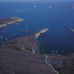
Il-Kalanka It-Tawwalija/Kalanka Bay
Another kept secret swimming area for Locals, the Kalanka is another gem of the south with remote access, with an unpaved road no where near hospitality or catering facilities as yet. A small hotel with agro-tourism concept is being constructed next to the beach, with a newly planned parking area for bathers which will ease access and provide a catering point in the area.
The beach is accessed by a long staircase and has a flat rocky surrounding, with an inlet caved in by sea erosion. Ladders are available to access the sea and high ground for jumpers are accessible.
Il-Kalanka tal-Qali/Peters Pool
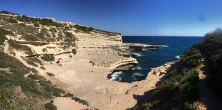
This inlet formed by centuries of sea erosion, transformed it into one of the most beautiful and natural swimming pools in southern Malta.
On days with northerly winds, the sea at Peters Pool is crystal clear with an amazing azure and celestial colours reflecting on the rocky surrounding, excellent for snorkelling. The flat rocks around Peter’s Pool provide perfect sunbathing areas, and the high rocks offer some shade from the strong sun. Ladders are available to access the sea.
The area is not even close to any shop or catering facilities, as it is completely off grid and natural. Due to its remote location, it is advised that bathers make sure that they bring all what is needed to spend the time on the beach, like water, food and sun-cream.
Recently a makeshift fence was erected to prevent bathers from crossing over the foot-cliffs, as falling rocks caused by wind/sea erosion from the cliff sides are frequent, a never-ending natural cause. Plans to erect an iron-mesh is planned to secure the beach from this kind of danger.