
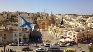
Marsaxlokk. also known as ‘Portus Hercules’ in Marsaxlokk Bay is a traditional fishing village in the most South Eastern area of Malta.
Situated in an inner harbour it is very popular with locals and tourist for its unique characteristics pushes its popularity into international level.
The meaning of Marsaxlokk comes from the Semitic word, Marsa, which means Harbour and Xlokk, which is the Maltese word for south-east thus Harbour in the Southeast.
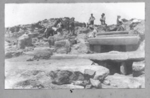
In ancient time the place was a marshland due its lowland with seasonal tides, evidence of this is in a small nature reserve known as Il-Maghluq where a small marsh survives. Later periods during the first immigrants coming from nowadays Sicily inhabiting the Islands regarded this territory was always seen as a vantage point for early inhabitants that dates back 4000CE. Proof is found northeast of the area at a place called Tas-Silġ and another Neolithic temple at Xrobb l- Ghagin Cliffs was also found in the 19 th Century.
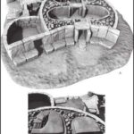 At the hilltop of Tas-Silġ also known as Juno Heights which relates to a temple found here. This temple is multi layered from different periods as early as Neolithic era. In later periods eviden of Phoenician, Carthaginians, Greek and Roman Temple structures were found on top of each other. Ancient artifacts indicate that these temples where dedicated to the various gods Like Astarte the most important Phoenician god and later the Roman Juno wife of Jupiter. This change of worship also puts the direct involvement of the Islands during the Punic Wars between Rome and Carthage.
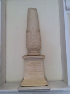
But the most important find were a pair of ornamental pillars or Cippi with engravings dedicated to the god Melqart or Hercules as the Greek counterpart. The Engravings found on these Cippus helped deciphering Phoenician texts by using the old Greek alphabet consequently solving a mystery for the archeological world. One Cippus is at the National Archeological Museum and one is at the Louvre Museum in Paris.
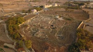
Other structures near the area during this period suggest this site apart from an important Location for worship, the area was a trading route throughout the various empires and ages. It is evident that these imposing structure were important for sea traders and its visibility used as shipping navigational points for the ancient seafarers. This place was also active during the Byzantine area as remains of basilica and a fortified settlement are found on top of all the ruins. By the arrival of the Aghlabids Arabs, easily conquered the Islands and layed waste to the area.
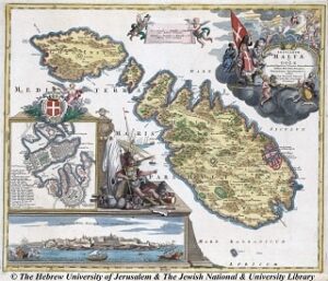
Little is known about the area during the Middle Ages after the invasions of the Goths and the Vandals, but surely after the destruction of this area it left the southern region exposed to frequent raids and attacks by Saracen pirates and later, raiders from the Barbary coast. Marsaxlokk was included in medieval portolan charts dating as far back as the 13th century mention as ‘marsascirocco’. During these times of Norman, Angevins and Aragonese no defenses or settlements where recorded or to be found until the 15th Century.
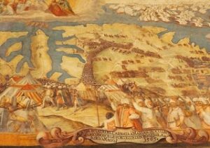
When the Spanish king lended the Islands to the Knights of St.John after being driven fom Rhodes by the Ottoman Emperor, the area back came to the importance in history. In 1547 a failed invasion force of Ottomans and Barbary Pirates landed in this harbour attempting to take the Islands. The 1565 invasion force of 200 ships and 40,000 troops of the Ottoman navy anchored and landed at Marsaxlokk, thus commenced the Great Siege of 1565. Three months later, the same area was a horrific scene of a fleeing Ottomans army, that were driven back in a bloody retreat to their safety of their ships.
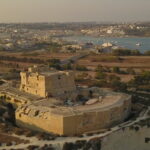 After such events the Knights of Malta understood the importance of the defence of the whole harbour was systematically fortified, with towers, batteries and fortresses by time. This chain of fortifications was intended to protect the vulnerable harbour. This included Vendome Tower, Delimara Tower, Ta’ Bettina Tower, Tumbrell Redoubt, Xrobb l-Ghagin Tower and entrenchment, Fort Rohan (San Lucian), Kavallerizza, Del Fargo redoubt and Tal-Wilga Battery. These defensive measures encouraged the population to sparsely settle in the marshy rural area. In 1614 these fortifications where put to the test when another invading force appeared and prevented a landing in the bay by Ottoman forces.
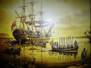
In late 1798 the Knight’s Order was at a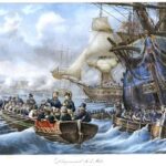 weak point and to their demise the French Navy on the horizon of Valletta appeared. By the sight of the vast armada many French knights capitulated and forced the Order to abandon the Islands without a fight. The only resistance was from Fort San Lucjan which prevented the French from anchoring in the harbour. But after a message was relayed to the defenders about the size of the armada the Fort ceased fire. Napoleon’s navy entered Marsaxlokk, and landed an army on the coast.
Two years Later an Invading Force of the British Navy came to the aid of the Maltese Rebellion under Horatio Nelson to expel the French from the Island during the British Blockade.
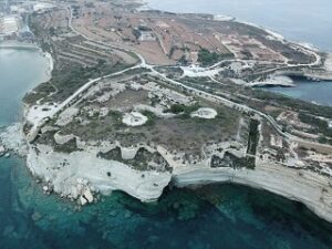
Soon after 1806 when the Islands where handed over to the British, its military commanders understood the importance of the strategic yet vulnerable harbour and increased its defence by upgrading the fortifications left by the Knights. along the 19th Century Delimara Peninsula became a militarized zone with the construction of barracks and camps complemented with four fortresses to secure any sea invasion.
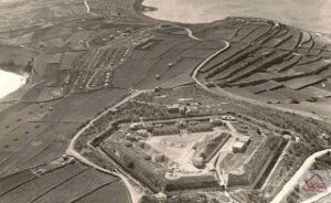
These being St.Paul Battery, Fort tas-SIlg, Wolseley Battery and Delimara Fortress. Delimara Tower, Xrobb l-Ghagin Tower and Tombrell redoubt were demolished to make way for the line of sight of the guns of the new fortresses.
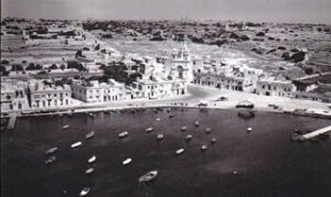
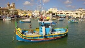
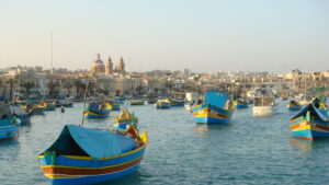
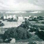 Around 1846, the first houses began to be built in Marsaxlokk, as fishermen from Żejtun and Zurrieq settled there permanently. Most houses were built by the shoreline a few meters from their berthed boats.
Others opted to farm land and grow crops in more rural areas above the coast. Most lands were mostly leased by private nobility or church who owned some large houses that they used as a holiday resort from their usual lifestyle.
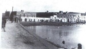
Life was simple and quite, during which the harbour was being explored and studied which proved to be pristinely fertile sea life which provided the livelihood of families. Some even ventured to sell their catches into nearby villages to make a living. As time went by some fishermen exploited fishing and improvised to build bigger boats to faraway further into the open blue. This type of serenity and industry kept attracting more people to inhabit the new settlement and as population reached the hundreds ,community duties started to take over.
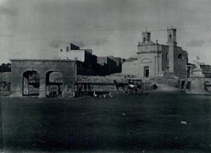
At the end of the 19th century, a church by the seashore was built to provide the spiritual needs of the fishermen and their families. The construction of the parish church started in 1890. It was built as a realization of a promise made by Marquees Testaferrata after she was saved from a violent storm at sea. The church was originally built in arectangular form with the designs. Marsaxlokk became an independent parish in 1897. The feast of our lady of Pompeii is held on the last Sunday of July. It includes a procession with the statue and a firework display.
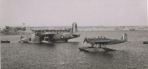
In WW1 no involvement was recorded and was relatively peaceful. In the 1930s, Marsaxlokk bay was used as a Seaplane Port for British and Italian companies ferrying people, cargo and postal services to nearby Mediterranean Places. A seaplane Hangar is still standing today next to Ghar Ahmar beach were today it is leases to a Tuna fish farm company.
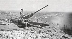
During the Second World War, Marsaxlokk Bay was prepared for the worst as a sea Invasion By Italian and German Forces was imminent. Fortunately Operation Hercules never materialized and relieved the situation. But the air battles were intense, many anti air-batteries where erected for air raids that were on a daily basis.
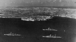
In November 1943 the Italian Regia Marina defected from Italian bases and rushed to surrender in Malta avoiding German capture. The Main Fleet anchored under the Guns of Marsaxlokk Fortresses until the surrender was formally announced.
After the wars the Islands came to a relative Peace until it achieved its Independence and Republic later in the 20 the Century. The Village population grew from a few families to hundreds of inhabitants mostly investing in the fishing industry and evolving the traditional fishing methods with improvised methods and gear. this also includes farming which is also a sector that is lightly mentioned throughout history. The hardships and loss of live are to be also remembered and taken into account in what its people has enduring during these times.
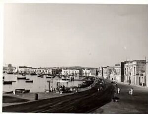
Electricity came in 1957 and water services came years later. So did Public Transport, but roads and infrastructure where still way behind during this period until late 60s. Inhabitants relied on fresh waters from valley springs or from a Faucet right next to the Washer’s Pit inside the square. The increase of fishing boats meant the industry was flourishing and later the larger fishing boats began to appear which signaled the rate of increase of this industry.
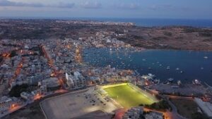
Sports was also given importance during this period mostly Water Polo and Football. Makeshift football pitches were setup to practice this sport until a proper pitch was built near Kavallerizza area thus after splinter teams united and formed the Marsaxlokk Football Club in 1949. Competing on National level, today the club achieved all honors the highest being that the Premier in 2006. Such success is equivalent to waterpolo as its popularity matched that of its counterpart and was successful for numerous years and achieved many honors. Marsaxlokk Aquatic Sport Club was founded in 1952 and have practiced in the waterpolo pitch close to the Qrejten Point.
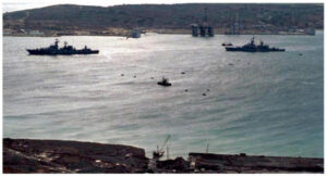
In 1989, the famous summit meeting between Soviet and US leaders Mikhail Gorbachev and George W. Bush was held on board a ship anchored in the bay ending in the Cold War right in these waters. The Harbour later saw the construction of two Malta Freeport Terminals and the construction of Power Stations to supply the nation’s energy supply at a cost of devouring the local natural ecological and safety of this once beautiful harbour.
Nowadays although much development and progress has been affected in this village, It battles to keep its traditional Icons and characteristics amongst the modern challenges being
faced in the new century. From a quite village Marsaxlokk with its panoramic views, its has continuously evolved into an ever increasing popular resort.
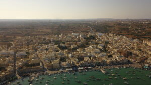
Many sectors apart from fishing has evolved like the Daily market and the Sunday Fish Market, Catering is another sector provided from numerous restaurants around the harbour which are supplied by daily catches. Guesthouses and Hotels are also slowly emerging to accommodate resident tourism.
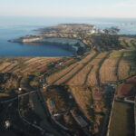 Five small beaches and rocky swimming zones attracts thousands of people in summer season and in winter visitors seek its countryside on the high ground in Delimara overlooking the village in its natural peacefulness.
When summing up all this development the area is becoming more limited to accommodate and to create a balance to all these sectors to thrive in harmony. The necessity of public open spaces, parking areas, walking spaces, recreational places, waste and traffic management has become the major present issues. Fortunately after lengthy studies, decisions are taken by Local Government to implement projects that provides all the Infrastructure to grant all the necessary needs and safety of Marsaxlokk.
All this In the hopes –
- to provide a balanced local economy
- better environment for its Xlukkajri Inhabitants
- preserve its heritage
- cherish tradition
- a better touristic product
- a Marsaxlokk to be proud
- the preservation of the Maltese Identity